
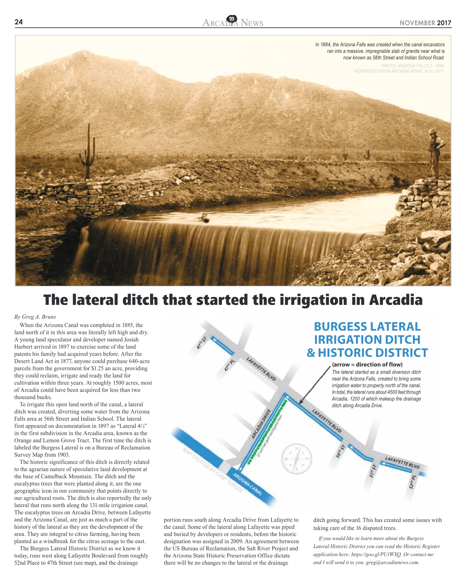
24 NOVEMBER 2017 ARCAD A NEWS By Greg A. Bruns When the Arizona Canal was completed in 1885, the land north of it in this area was literally left high and dry. A young land speculator and developer named Josiah Harbert arrived in 1897 to exercise some of the land patents his family had acquired years before. After the Desert Land Act in 1877, anyone could purchase 640-acre parcels from the government for $1.25 an acre, providing they could reclaim, irrigate and ready the land for cultivation within three years. At roughly 1500 acres, most of Arcadia could have been acquired for less than two thousand bucks. To irrigate this open land north of the canal, a lateral ditch was created, diverting some water from the Arizona Falls area at 56th Street and Indian School. The lateral first appeared on documentation in 1897 as “Lateral 4½” in the first subdivision in the Arcadia area, known as the Orange and Lemon Grove Tract. The first time the ditch is labeled the Burgess Lateral is on a Bureau of Reclamation Survey Map from 1903. The historic significance of this ditch is directly related to the agrarian nature of speculative land development at the base of Camelback Mountain. The ditch and the eucalyptus trees that were planted along it, are the one geographic icon in our community that points directly to our agricultural roots. The ditch is also reportedly the only lateral that runs north along the 131-mile irrigation canal. The eucalyptus trees on Arcadia Drive, between Lafayette and the Arizona Canal, are just as much a part of the history of the lateral as they are the development of the area. They are integral to citrus farming, having been planted as a windbreak for the citrus acreage to the east. The Burgess Lateral Historic District as we know it today, runs west along Lafayette Boulevard from roughly 52nd Place to 47th Street (see map), and the drainage portion runs south along Arcadia Drive from Lafayette to the canal. Some of the lateral along Lafayette was piped and buried by developers or residents, before the historic designation was assigned in 2009. An agreement between the US Bureau of Reclamation, the Salt River Project and the Arizona State Historic Preservation Office dictate there will be no changes to the lateral or the drainage ditch going forward. This has created some issues with taking care of the 16 disputed trees. If you would like to learn more about the Burgess Lateral Historic District you can read the Historic Register application here: https://goo.gl/PU1WXQ. Or contact me and I will send it to you: greg@arcadianews.com. The lateral ditch that started the irrigation in Arcadia In 1884, the Arizona Falls was created when the canal excavators ran into a massive, impregnable slab of granite near what is now known as 56th Street and Indian School Road. PHOTO: ARIZONA FALLS C. 1890. REPRINTED FROM ARCADIA NEWS , NOV. 2011. The lateral started as a small diversion ditch near the Arizona Falls, created to bring some irrigation water to property north of the canal. In total, the lateral runs about 4500 feet through Arcadia, 1200 of which makeup the drainage ditch along Arcadia Drive. MAP CREATED BY GABE TURNER BURGESS LATERAL IRRIGATION DITCH & HISTORIC DISTRICT (arrow = direction of flow)
4 3 4 6 N o r t h 4 0 t h S t r e e t P h o e n i x , A r i z o n a L i b b y C o h e n | 6 0 2 . 2 9 1 . 1 4 4 6 5 B R | 5 . 5 B A | 5 , 4 6 7 S Q F T $ 1 , 7 9 5 , 0 0 0 | P r i v a t e L i s t i n g 5 2 9 0 E a s t E x e t e r B o u l e v a r d P h o e n i x , A r i z o n a L i b b y C o h e n | 6 0 2 . 2 9 1 . 1 4 4 6 1 0 B R | 1 2 . 5 B A | 1 8 , 9 0 0 S Q F T $ 1 6 , 8 5 0 , 0 0 0 | M L S # 5 5 4 1 3 7 8 5 1 0 2 N o r t h W i l k i n s o n R o a d P a r a d i s e Va l l e y , A r i z o n a K a r e n P r a t t e | 6 0 2 . 2 2 8 . 4 3 7 7 5 B R | 7 B A | 8 , 7 5 2 S Q F T $ 4 , 5 0 0 , 0 0 0 | M L S # 5 6 7 0 3 5 5 For More Photos and Information on These and Other Fine Properties, Visit WaltDanley.com Walt Danley Christie’s International Real Estate 5 1 4 4 E a s t P a l o m i n o R o a d P h o e n i x , A r i z o n a N a n c y K a p l a n | 6 0 2 . 6 1 5 . 1 2 4 6 4 B R | 6 B A | 7 , 2 5 8 S Q F T $ 5 , 2 0 0 , 0 0 0 | M L S # 5 5 4 8 3 8 4 7 0 B i l t m o r e E s t a t e s P h o e n i x , A r i z o n a L i b b y C o h e n | 6 0 2 . 2 9 1 . 1 4 4 6 5 B R | 5 . 5 B A | 6 , 4 7 2 S Q F T $ 2 , 0 0 0 , 0 0 0 | M L S # 5 6 7 5 2 4 0 3 9 4 0 E a s t C r i t t e n d e n L a n e P h o e n i x , A r i z o n a B a k e r P a r k S a l e s | 6 0 2 . 8 1 9 . 8 4 7 5 3 B R | 2 . 5 B A | 3 , 5 8 9 S Q F T $ 1 , 3 9 9 , 0 0 0 | M L S # 5 5 9 1 8 3 0 Representing Arizona’s Finest Properties VillasatBakerPark.com